Attention: Please take a moment to consider our terms and conditions before posting.
One for the railway enthusiasts on here

Masterbrew
Posts: 277
I've walked under the bridge in Ransome Walk many times over the years but only recently heard that it was built for a narrow gauge railway that ran from the ballast pit that is now the site of The Valley, down to a wharf on the River Thames.
The route of it can be traced on this old map https://maps.nls.uk/view/102343435
The route of it can be traced on this old map https://maps.nls.uk/view/102343435
9
Comments
-
I suspect a lot of railways don't follow their original plans any more. The one that gets me is the Fenchurch Street line which originally ran to Hackney rather than Essex (You can still see where the original route peeled off at Bow Triangle). If anyone's interested, I can thoroughly recommend the book Mr Briggs Hat which is about the first railway murder and took place on that line.0
-
That is totally fascinating thank you. So the Valley was a bit like the quarry by Fraser Road in Erith and used in the same way for ballast for ships. And like at Erith, it had a rail track to the Thames to load the ballast at Erith,. I think the ballast had many uses one of which during the first world war was two be sent to Newcastle to the foundries for the manufacture of artillery..3
-
This is from 1879.

I'll guess that the church in the background is St Luke's with the chalk cliffs of what is now The Heights and The Valley in front.
There is an apparent bend in the railway line which isn't replicated on the 1870 OS map.
6 -
Could these be the remnants?
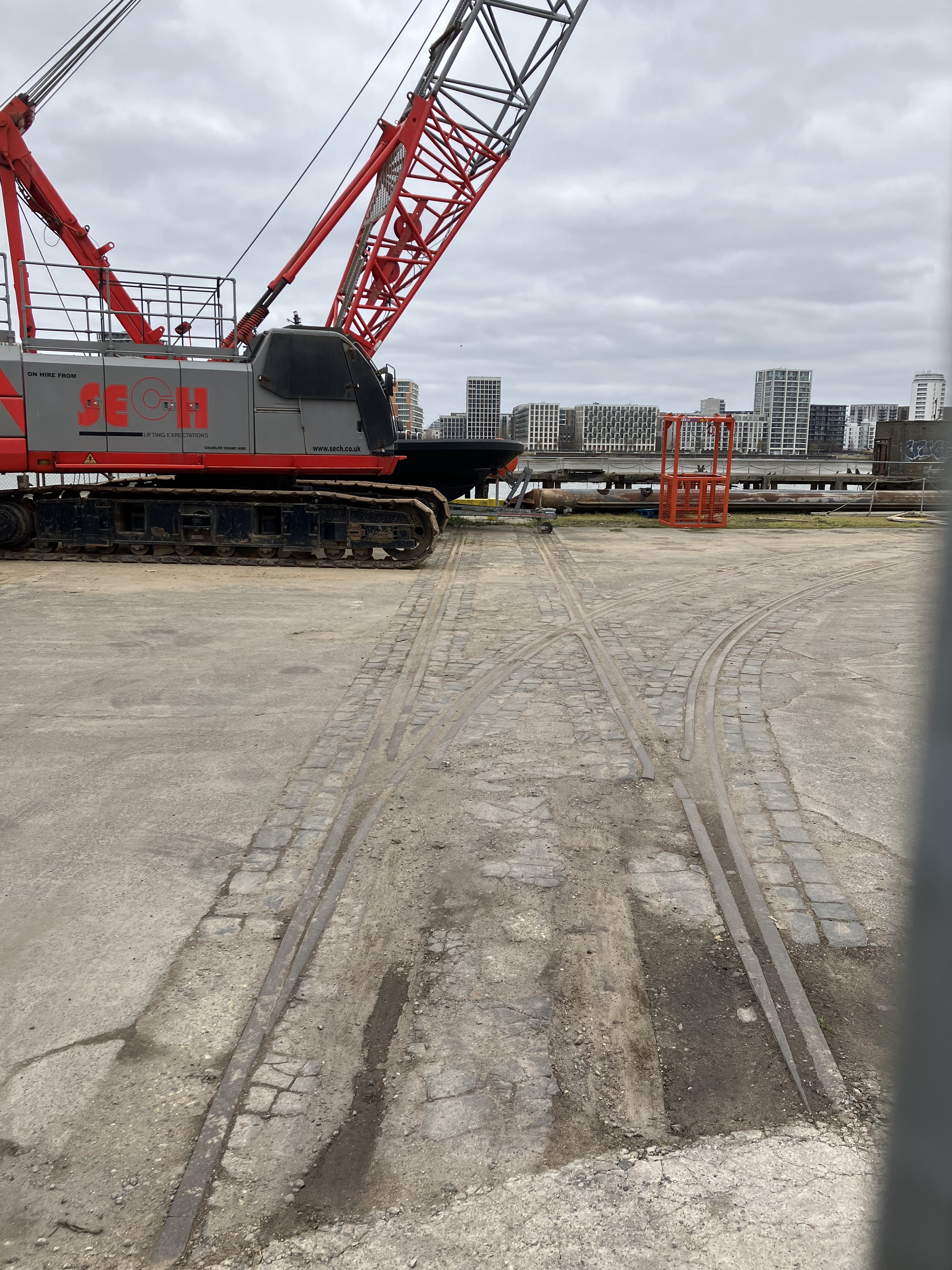
 5
5 -
What's also interesting about that map is that it's before the railway line between Greenwich and Charlton was built, so that the only service to Charlton was via Blackheath.0
-
Should you be allowed to post stuff like that before the 9pm watershed?Baldybonce said:Could these be the remnants?8 -
That confused me slightly as I thought London Bridge to Greenwich was considered to be the world’s first commuter line. Unless it stopped at Greenwich and the line to Charlton via Blackheath was freight-only.killerandflash said:What's also interesting about that map is that it's before the railway line between Greenwich and Charlton was built, so that the only service to Charlton was via Blackheath.1 -
The line from London Bridge originally terminated at Greenwich; the Astronomer Royal wouldn't permit it extending eastwards, as tunnels by Greenwich Park could disturb instruments at the Royal Observatory. When that moved to Hurstmonceux, the line was extended to meet the existing line from Blackheath to Charlton.Hex said:
That confused me slightly as I thought London Bridge to Greenwich was considered to be the world’s first commuter line. Unless it stopped at Greenwich and the line to Charlton via Blackheath was freight-only.killerandflash said:What's also interesting about that map is that it's before the railway line between Greenwich and Charlton was built, so that the only service to Charlton was via Blackheath.6 -
Not sure about dates but I know the London Bridge to Greenwich line is built entirely on a viaduct, the longest in the UKHex said:
That confused me slightly as I thought London Bridge to Greenwich was considered to be the world’s first commuter line. Unless it stopped at Greenwich and the line to Charlton via Blackheath was freight-only.killerandflash said:What's also interesting about that map is that it's before the railway line between Greenwich and Charlton was built, so that the only service to Charlton was via Blackheath.3 -
As Masterbrew said, the Greenwich Line initially didn't go any further, so the first services from London to Woolwich went via Blackheath and Charlton.Hex said:
That confused me slightly as I thought London Bridge to Greenwich was considered to be the world’s first commuter line. Unless it stopped at Greenwich and the line to Charlton via Blackheath was freight-only.killerandflash said:What's also interesting about that map is that it's before the railway line between Greenwich and Charlton was built, so that the only service to Charlton was via Blackheath.
0 -
Sponsored links:
-
Great pic .. where did you find it?Dave Rudd said:This is from 1879.
I'll guess that the church in the background is St Luke's with the chalk cliffs of what is now The Heights and The Valley in front.
There is an apparent bend in the railway line which isn't replicated on the 1870 OS map.0 -
Pornhub7
-
For dates -The London and Greenwich Railway opened between Deptford and Spa Road (Bermondsey) in early 1836 - it extended to London Bridge station later in 1836, and to the current Greenwich station in 1840.The South Eastern Railway's North Kent line (Lewisham - Charlton - Woolwich - Strood) opened in 1849.The two were connected in 1878.(To be really pedantic, the first railway service to Woolwich was in 1847, to North Woolwich station and then via the railway company's ferry to get to the south bank...)1
-
And when they did eventually extend it east they had to dig up a load of old sailors from the Greenwich Hospital graveyard - including some who were in the Battle of Trafalgar - who were then interned in the East Greenwich Pleasuance.killerandflash said:
As Masterbrew said, the Greenwich Line initially didn't go any further, so the first services from London to Woolwich went via Blackheath and Charlton.Hex said:
That confused me slightly as I thought London Bridge to Greenwich was considered to be the world’s first commuter line. Unless it stopped at Greenwich and the line to Charlton via Blackheath was freight-only.killerandflash said:What's also interesting about that map is that it's before the railway line between Greenwich and Charlton was built, so that the only service to Charlton was via Blackheath.3 -
Yes, that's a lot of effort to go to just to stop the line at Greenwich. Can't see it getting approval today !fat man on a moped said:
Not sure about dates but I know the London Bridge to Greenwich line is built entirely on a viaduct, the longest in the UKHex said:
That confused me slightly as I thought London Bridge to Greenwich was considered to be the world’s first commuter line. Unless it stopped at Greenwich and the line to Charlton via Blackheath was freight-only.killerandflash said:What's also interesting about that map is that it's before the railway line between Greenwich and Charlton was built, so that the only service to Charlton was via Blackheath.0 -
I use that Internet thingy. Amazing what you can find.stonemuse said:
Great pic .. where did you find it?Dave Rudd said:This is from 1879.
I'll guess that the church in the background is St Luke's with the chalk cliffs of what is now The Heights and The Valley in front.
There is an apparent bend in the railway line which isn't replicated on the 1870 OS map.1 -
The North Kent Railway (Blackheath to Rochester via Woolwich) was peppered with branches, sidings and tramways that served the many industries along the route, that fronted the Thames. These were gradually reduced and removed as the industries closed or used road transport instead. Sidings at stations became car parks for commuters.
Today the only remaining branchline is that to Angerstein Wharf, for aggregat transfer and stockpiling, which leaves the North Kent Line west of Charlton.
Look them up on the NLS georeferenced maps website.1 -
Out of curiosity about Charlton Ballast Wharf, I found this on a web search -
 by Francis Seymour Leslie, dated 1894.On the 'mutual art' website - there's a few other river scenes from the Woolwich / Charlton patch of similar era, although the website only lets you look at a few things before you have to log in (or open a new private window...)1
 -
There was also a line from Lewisham Road (the station is now Aladdin's Cave) to Greenwich Park (where the Ibis is) which ran from 1888 to 1917.killerandflash said:What's also interesting about that map is that it's before the railway line between Greenwich and Charlton was built, so that the only service to Charlton was via Blackheath.
Seems the Victorians didn't care about anything East of Greenwich. 😃
0 -
At least they didnt stop at London Bridge like every government since.Friend Or Defoe said:
There was also a line from Lewisham Road (the station is now Aladdin's Cave) to Greenwich Park (where the Ibis is) which ran from 1888 to 1917.killerandflash said:What's also interesting about that map is that it's before the railway line between Greenwich and Charlton was built, so that the only service to Charlton was via Blackheath.
Seems the Victorians didn't care about anything East of Greenwich. 😃0 -
Sponsored links:
-
You can still see the old railway embankment at the Lewisham end of the St Johns station platform and if you look on Google Maps you can make out where the line ran behind the Richard 1st pub - there's a load of allotments there now.Friend Or Defoe said:
There was also a line from Lewisham Road (the station is now Aladdin's Cave) to Greenwich Park (where the Ibis is) which ran from 1888 to 1917.killerandflash said:What's also interesting about that map is that it's before the railway line between Greenwich and Charlton was built, so that the only service to Charlton was via Blackheath.
Seems the Victorians didn't care about anything East of Greenwich. 😃0 -
Off_it said:You can still see the old railway embankment at the Lewisham end of the St Johns station platform and if you look on Google Maps you can make out where the line ran behind the Richard 1st pub - there's a load of allotments there now.And on Brookmill Road - I'm told the bridge was still there when parents moved to Lewisham in the 1960s.More on the Greenwich Park branch on 'disused stations' website.3